Kiteloopers - Kitesurfing spots, trips and destinations worldwideKiteloopers - Kitesurfing spots, destinations and kite trips worldwide
MapDestinationsBlog
Log in

Progetto

  • Info
  • Contatto

Legale

  • Termini
  • Privacy
  • Cookie
  • Note legali
  • Supporto

Community

  • Spot
  • Blog
  • Scuole
  • Istruttori
  • Alloggi
  • Viaggi
  • KiteMarket

Social

  • Instagram
  • Facebook
© 2026 Kiteloopers — Tutti i diritti riservati
Saint-Valery-en-Caux

Saint-Valery-en-Caux

Plage de Saint-Valery-en-Caux

France · Normandie (Seine-Maritime)

Intermedio
Oct → Mar
23.4 nd
↓ Mosso
↑ Mosso

Saint-Valery-en-Caux

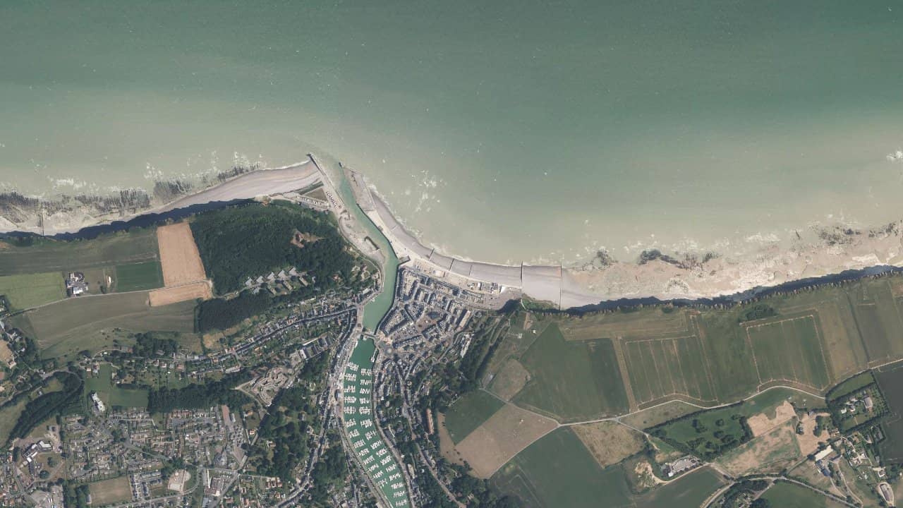
Nestled in the hollow of the high cliffs of the Alabaster Coast, the Saint-Valery-en-Caux beach is a unique spot, with a very marked port and mineral atmosphere. Located in immediate proximity to the port, this pebble beach offers decidedly maritime navigation in a spectacular setting, between white cliffs, dikes, and an open horizon over the English Channel. It is not an easy or tolerant spot, but it can offer great committed sessions when the wind, swell, and tide are well synchronized.

Vento live e previsioni

Windy
Apri le previsioni Windguru

Statistiche climatiche — medie mensili

Medie storiche per mese — non è una previsione live.

Posizione

Informazioni dettagliate

Navigation takes place in open sea, on a pebble beach highly dependent on the tide and influenced by the port configuration. At low tide, entry is technical due to the pebbles and steep slope. At high tide, the depth quickly becomes sufficient but the space at the shore is very limited. The dominant wind blows from west to northwest, arriving side to side-onshore. The water conditions are generally choppy to rough, with short and sometimes disorganized waves due to the dikes and terrain.

Vedi sulla mappa
Mobile app

Kiteloopers in your pocket

Spots, live weather, sessions & community.

Scan to download the app

App StoreGoogle Play

Rischi e sicurezza

  • Pebble beach: technical entry and exit, booties highly recommended.
  • Proximity to the port and dikes: strictly stay within authorized areas.
  • Wind sometimes disturbed by the terrain and infrastructure.
  • Real currents depending on the tide.
  • No official rescue: independent navigation is essential.

Condizioni di navigazione

Alta marea
Tipo di acqua
chop
Profondità
Si tocca
Navigabilità
Sì
Bassa marea
Tipo di acqua
chop
Profondità
Parziale
Navigabilità
Tec.

Vento ideale

NENENESO

Spot vicini

Vedi sulla mappa

Caricamento…

Recensioni dei kitesurfer

Chargement des avis...
← Torna alla ricerca
Vedi sulla mappa