Kiteloopers - Kitesurfing spots, trips and destinations worldwideKiteloopers - Kitesurfing spots, destinations and kite trips worldwide
MapDestinationsBlog
Log in

Project

  • About
  • Contact

Legal

  • Terms
  • Privacy
  • Cookies
  • Legal notices
  • Support

Community

  • Spots
  • Blog
  • Schools
  • Instructors
  • Accommodations
  • Trips
  • KiteMarket

Social

  • Instagram
  • Facebook
© 2026 Kiteloopers — All rights reserved
Llangennith

Llangennith - Broughton Bay

Royaume-Uni

🎓Inter · Adv
🌊Choppy
💨24.6 kt
☀️7.6°C

Llangennith

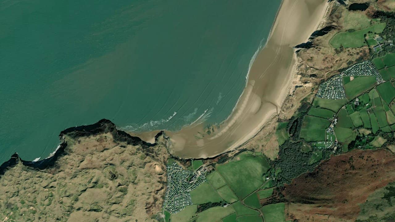
Broughton Bay, in Llangennith on the Gower, is a large sandy beach open to the west coast of Wales. It is a popular spot for its vast setting, easy access from Llangennith, and its potential when the swell and wind align.

The spot remains more discreet than Llangennith, but it attracts riders when conditions become favorable. It features a very exposed environment, with a beautiful beach and a practice that heavily depends on the tide and wind quality.

The wind data shown here comes from ERA5 (via Open-Meteo) over 4 years, reprocessed to reflect realistic conditions.
👉 Average wind has been calibrated to avoid the usual underestimation of models.
👉 Gusts have been corrected by a median ratio to avoid unrealistic extreme values.
👉 Each day is summarized by the median wind (P50) observed during useful hours (8am–8pm), then classified into wind ranges.
👉 The weighted mode mixes average wind and gusts to best reflect felt wind.

  • 🟢 10–16 kts: light but sailable wind (especially on foil).
  • 🟡 16–22 kts: ideal range, comfortable conditions for most.
  • 🔴 22–28 kts: strong wind, reserved for experienced riders.
  • 🟣 28+ kts: extreme conditions, committed riding.

Location & Points of interest

Useful information

Water type
Depth
Rideability
High tide
chopchop
Standable
Yes
Low tide
wavewave
Partial
Tech.
Riding conditions

The spot mainly works with a wind from the SE to SW sector, with a favorable tendency in side-on to side-shore depending on the exact angle of the wind on the bay. The water surface is rarely perfectly flat, as the beach is exposed and the swell easily comes in; thus, one often navigates in a mix of chop and small waves, with cleaner quality at mid-tide than at low tide. Surf sources indicate that Broughton requires a good swell to work well and is better around mid-tide at high tide, confirming it as a more technical spot than a simple beginner beach break.

Entry is made from the large sandy beach, with a takeoff area to keep wide to avoid disturbing walkers and site users. The area is exposed and the wind can be irregular near the shore when it passes over the dunes or coastal relief. At low tide, the space is larger but navigation becomes less interesting and some areas may become impractical depending on the swell orientation. At high tide, the spot gains more consistency, but one must remain attentive to the shorebreak and bottom variations.

Broughton Bay does not resemble a perfect flat spot; it is rather an open coast spot, with more challenging conditions as the wind picks up. The most comfortable navigation area remains one that allows going offshore without staying in the breaking zone close to the shore. The spot is therefore more suited to riders capable of managing a moving water surface and a sometimes physical return to shore.


Ideal wind
SW
N
NWdominant
Wdominant

The spot works best with a wind from SE to SW, or a sufficiently clean flow to remain side-shore to side-on. A regular intensity, around 20 to 30 knots, is needed to compensate for the bay's exposure and maintain a solid planning takeoff.

The best sessions occur when the wind is steady but not too gusty, with moderate swell and a tide around mid-cycle. It is under these conditions that Broughton Bay becomes the most readable and enjoyable.

Sea state

The water surface is generally of the chop type, with sections of wave when the swell comes in properly. It is not a regular flat spot, as the beach is open and the sea quickly takes on relief as the wind picks up.

At low tide, the water can appear more messy and less clean, while at mid-tide the waves become more readable and navigation more interesting. When conditions align, the spot can offer real surf sections, but one must accept a mobile and sometimes quite powerful water surface.

Sea currents

Currents can be strong near flow areas and sectors influenced by swell and tide. Reports indicate the presence of rips and rocks, which necessitates monitoring the return to shore and breaking zones.

The spot is more interesting at mid-tide and high tide, while low tide often reduces the quality of navigation. Therefore, one must time their session for the right tide slot to avoid navigating in an area that is too flat, too exposed, or too disturbed by the current.

Recommended kite size

In classic navigation, the most useful sizes often range between 7 m² and 10 m², with a very frequent session around 8 m² or 9 m² when the wind hovers around 23 knots. Heavier riders may aim for 10 m² or 11 m² if the wind remains irregular.

When Atlantic depressions settle in, it may also be necessary to go down to 7 m², especially if the gusts increase and the sea forms more.

Weather & wind

The dominant wind useful for kitesurfing often comes from the W to NW sector in the region, but Broughton Bay also responds well to SE to SW flows depending on the weather situation. The cleanest conditions are generally associated with a side-on to side-shore wind, as too much onshore wind quickly degrades the quality of the water surface.

In the Gower, wind gusts are often linked to Atlantic disturbances, with marked gusts and a sea that forms quickly. The local data provided, around 23.3 knots, corresponds well to a usable wind range for this type of exposed spot.

Climate

The climate of the Gower is oceanic, with cool, wet, and windy winters, and generally mild summers. The best times to kite are often in autumn and winter, when Atlantic depressions more regularly bring wind and swell. The month of December stands out as a good time, which fits well with the functioning of this exposed coastline.

In summer, temperatures are more pleasant but wind windows can be more irregular. The spot remains accessible for a large part of the year due to its exposure and the frequency of Atlantic weather systems.

Depth

The depth is gradual with a mostly sandy bottom, but the environment remains exposed and some areas may present rocks or irregularities near the edges. One can generally stand in a good part of the water entry, but the configuration changes with the tide and swell.

The spot is more practical at mid-tide and high tide, when the usable area is more consistent. At low tide, the playground becomes less clean and some areas may be too shallow or less comfortable for takeoff and return.

Water temperature

The water remains cold for a large part of the year, especially from November to April. In winter, a thick wetsuit, often 5/4 or 5/3, is generally necessary, with gloves and booties depending on the rider's sensitivity.

In summer, the water becomes more bearable but remains cool compared to many more southern destinations. A lighter wetsuit may suffice on some days, but the feel depends a lot on the wind and the spot's exposure.

Kitesurfers reviews

Chargement des avis...

Leave a review

0/500 characters

Your review will be reviewed before publication.

BookFind a schoolRent gear
View on map

Quick summary

  • 🌍 Country: Royaume-Uni
  • 📍 Area / Region: Wales
  • 💰 On-site budget: $
  • 🎓 Minimum level: Intermediate
  • 🌤️ Ideal season: Déc
  • 🪁 Recommended kite sizes: 7 m² – 11 m²

⚠️ Risks & Safety

  • Rips can form, so keep a margin offshore.
  • Rocks are mentioned in the area, especially near exposed sectors.
  • The return to shore can become physical with the swell and tide.
Need help?
  • 🛡️ Secure booking
  • 🌬️ Advice based on season and wind
  • 🧭 Partner guides & schools
Contact support →

Nearby spots

View on map

Loading…

← Back to search