Foz

Foz - La Charca (Rio Masma)

Espagne

🎓Déb · Inter · Conf
🌊Flat
💨
☀️

Foz

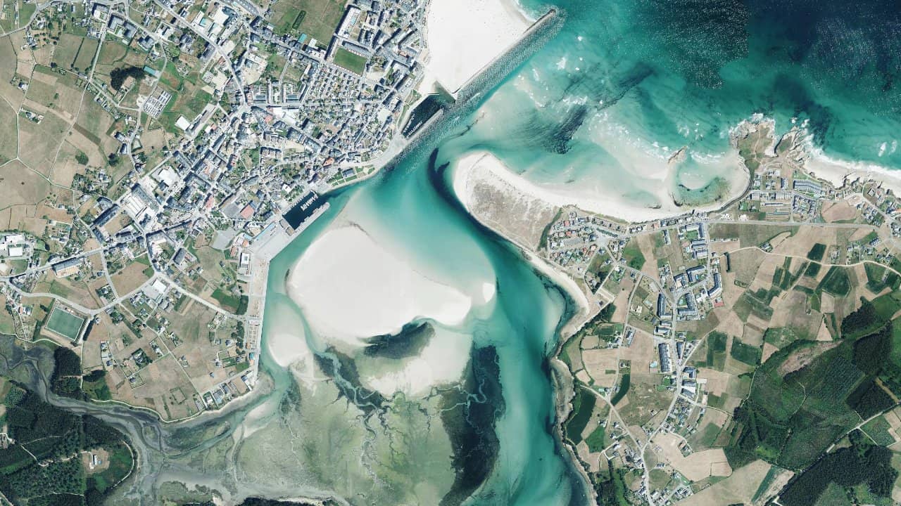
La Charca, located in Foz in northern Galicia, is an estuary kitesurfing spot that offers a unique setting between the Masma River and the Atlantic Ocean. It is a favorite place for local riders due to its easy access and semi-protected conditions that allow for progression in a less exposed environment than traditional coastal spots.

The area benefits from the exceptional geographical position of Galicia, located at the northwestern tip of Spain and directly exposed to Atlantic weather systems. The spot receives regular wind conditions and reliable swell, making it an interesting destination for kitesurfers seeking varied conditions.

Les données de vent affichées ici proviennent d’ERA5 (via Open-Meteo) sur 4 ans, retraitées pour refléter des conditions réalistes.
👉 Le vent moyen a été calibré pour éviter la sous-estimation habituelle des modèles.
👉 Les rafales ont été corrigées par un ratio médian afin d’éviter des valeurs extrêmes irréalistes.
👉 Chaque jour est résumé par le vent médian (P50) observé pendant les heures utiles (8h–20h), puis classé dans des plages de vent.
👉 Le mode pondéré mélange vent moyen et rafales pour refléter au mieux le vent ressenti.

  • 🟢 10–16 nds : vent faible mais navigable (notamment en foil).
  • 🟡 16–22 nds : plage idéale, conditions confortables pour la majorité.
  • 🔴 22–28 nds : vent fort, réservé aux riders expérimentés.
  • 🟣 28+ nds : conditions extrêmes, navigation engagée.

Localisation & Points d'intérêt

Informations utiles

Type d’eau
Profondeur
Navigabilité
Marée haute
chopchop
Pied
Oui
Marée basse
flatflat
Partiel
Oui
Conditions de navigation

La Charca offers a semi-protected water surface ideal for estuary sessions. The dominant wind comes from the west and northwest, creating conditions generally side-shore to side-on depending on the exact launch configuration. The estuary area allows for good progression with less turbulent conditions than on the exposed coast.

Launching takes place from the beach or accessible areas of the estuary. The water surface varies with the tides: at low tide, the spot offers more space with a gradual bottom, while at high tide, the water rises and creates more compact conditions. Riders should be attentive to estuary currents that can be pronounced, especially near the main channel. The launch area is generally clear, allowing for good use of the available space.

Vent ideal
Wdominant
NWdominant
SW

Ideal conditions at La Charca occur with a wind from the west to northwest blowing between 15 and 25 knots. These conditions create a regular side-shore allowing for smooth and safe navigation in the estuary. An established and constant wind is preferable to marked gusts that can make navigation difficult in the protected area.

The best sessions generally occur in late spring and early autumn, when Atlantic systems are stable and regular. A wind of 20 to 23 knots offers an excellent balance between power and control for most riders.

État de la mer

The water surface at La Charca is generally flat to slightly choppy depending on wind and tide conditions. In the estuary, the water is more protected than on the open coast, creating ideal conditions for progression and learning. During strong west winds, the water surface can become more agitated with small waves generated by local wind.

The Atlantic swell penetrates less easily into the estuary, meaning that conditions remain relatively smooth even when there is swell in open sea. This makes the spot particularly suitable for riders seeking flat water conditions or very small waves.

Courants marins

The spot is located in an estuary, which means that currents are influenced by the flow of the Masma River and Atlantic tides. The current is generally moderate to weak in the main navigation area, but it can become more pronounced near the channel where the water flows more forcefully.

Tides play an important role in the dynamics of the spot. At high tide, the water rises in the estuary and currents can reverse. At low tide, the outgoing flow is more pronounced. Riders must adapt their navigation according to these cycles and remain vigilant, especially beginners.

Taille de kite recommandée

For an average wind of 20-23 knots, recommended sizes vary according to the rider's weight and the type of conditions. Lighter riders (under 70 kg) can use kites of 9 to 11 m², while heavier riders (over 80 kg) will prefer 11 to 13 m².

In the estuary with semi-protected conditions, it is wise to have a range of sizes available to adapt your session to wind variations. A 10 m² kite is a good compromise for most intermediate riders. Beginners will benefit from a slightly larger kite for more stability.

Météo & vent

The wind regime at La Charca is dominated by Atlantic systems that pass through Galicia without major obstacles. Winds from the west and northwest are the most consistent and provide the best kitesurfing conditions. These winds are generally established and reliable, particularly during the summer season.

Galicia, positioned at the northwestern tip of Spain, receives all weather systems crossing the Atlantic, whether they come from the north or south. This means that the spot benefits from interesting variability with changing conditions but rarely without wind. Gusts can be pronounced, especially during frontal passages.

Climat

Galicia has an oceanic Atlantic climate with marked seasonal variations. Temperatures remain moderate throughout the year, with mild winters and temperate summers. The region receives significant rainfall, particularly in autumn and winter, contributing to the stability of weather systems.

The best time for kitesurfing extends from late spring to early autumn, with generally more stable and predictable conditions. The rest of the year remains excellent for experienced riders, but conditions become more random with more frequent storms.

Profondeur

The depth at La Charca varies depending on the position in the estuary and the tide cycle. In the main launch area, it is generally waist-deep to 1-2 meters from the shore. The depth gradually increases as you move away from the beach, reaching 3-5 meters in the middle of the estuary.

The bottom consists of sand and mud, typical of estuarine areas. This composition creates a relatively soft and safe bottom for falls. At low tide, some areas can become very shallow or even exposed, reducing the navigation space. At high tide, the water rises and offers more depth and space.

Température de l’eau

The water temperature in Galicia varies significantly by season. In summer (June to September), the water reaches its maximum temperatures around 16-18°C. In spring (April to May) and autumn (October to November), temperatures range between 13-16°C.

In winter (December to March), the water is colder with temperatures of 10-13°C. A 4/3 mm wetsuit is recommended year-round, with a 5/4 mm or thicker during winter months to stay comfortable during extended sessions.

Avis des kitesurfers

Chargement des avis...

Laisser un avis

0/500 caractères

Votre avis sera modéré avant publication

← Retour à la recherche