
Karikari Peninsula - Tokerau Beach
New Zealand
Karikari Peninsula
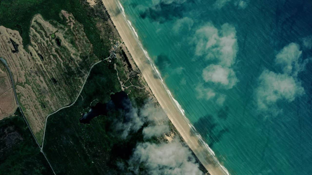
Tokerau Beach, on the Karikari Peninsula in New Zealand's Northland, stretches over 18 km of fine white sand. It is a popular spot for its easy take-off and stunning views of the Pacific Ocean.
To the north of the beach, there are small waves ideal for wave sessions, while to the south, the waves grow larger for more engaged riding. Locals also appreciate the calm atmosphere and the possibility of camping in a van right next to it.
Accessible via the Karikari Peninsula, it is an authentic place where wind and waves combine for varied sessions all year round.
Les données de vent affichées ici proviennent d’ERA5 (via Open-Meteo) sur 4 ans, retraitées pour refléter des conditions réalistes.
👉 Le vent moyen a été calibré pour éviter la sous-estimation habituelle des modèles.
👉 Les rafales ont été corrigées par un ratio médian afin d’éviter des valeurs extrêmes irréalistes.
👉 Chaque jour est résumé par le vent médian (P50) observé pendant les heures utiles (8h–20h), puis classé dans des plages de vent.
👉 Le mode pondéré mélange vent moyen et rafales pour refléter au mieux le vent ressenti.
- 🟢 10–16 nds : vent faible mais navigable (notamment en foil).
- 🟡 16–22 nds : plage idéale, conditions confortables pour la majorité.
- 🔴 22–28 nds : vent fort, réservé aux riders expérimentés.
- 🟣 28+ nds : conditions extrêmes, navigation engagée.
Localisation & Points d'intérêt
Informations utiles
Tokerau Beach faces east, perfect for east, northeast, and southeast winds that become side-on to side-shore depending on the precise direction. Take-off is easy on the wide, clean sand, with space to lay down the kite without worry.
The navigation area extends over the 18 km of beach: to the north, shallow and choppy water suitable for beginners and freestyle, while to the south via Ramp Road, more consistent waves for wave riding. At low tide, the last 500 meters to the north offer a flat bottom ideal for practice, with assured footing.
In east wind, the water surface is choppy in the north and wavy in the south; tides have little influence on the spot but favor low tide for new riders. The local school Airzone uses the north for lessons, confirming the relative safety of this area.
Ideal conditions are with winds E, NE, SE at 15-25 knots, side-on from the beach for a smooth water surface and rideable waves.
The water surface varies from chop in the north to wave in the south, with small punchy waves starting in the north and larger ones in the south. Sandy bottom everywhere, suitable for kitesurfing.
Rips can form, especially in the presence of northeast swell. Currents are generally moderate but should be monitored near wave areas.
Tides have a moderate range; low tide exposes more sand but remains navigable.
Opt for sizes of 9 to 12 m² in typical winds of 15-25 knots; 7-9 m² for stronger days, and 11-13 m² when it calms down.
The dominant wind regime comes from the east, with typical speeds of 15-25 knots during the active season. There is no specific local name, but the Karikari Peninsula is known for its many windy days, more than the New Zealand average.
The NE and SE winds bring stable side-shore conditions, while pure east provides punchy cross-onshore conditions.
The subtropical climate of Northland offers pleasant temperatures year-round, with warm summers around 22-25°C and mild winters around 15-18°C. Rainfall is moderate, but isolated showers can occur.
The spot is rideable for 12 months, with a wind score of 69/100 and optimal conditions from January to December according to local data.
The depth is gradual with a sandy bottom everywhere. In the north, it is shallow for several dozen meters, ideal for beginners at low tide.
The water ranges between 16-18°C in winter and 20-23°C in summer; a shorty or 3/2 neoprene suit is suitable year-round.