Espagne
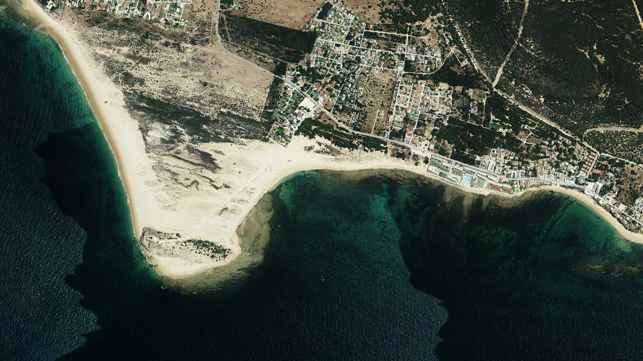
Playa de los Caños de Meca, in Los Caños de Meca, Andalusia, is a popular spot for its waves and its well-exposed coastal spot ambiance. It’s a playground well-known to riders who accept a bit of relief in the water and are looking for a more engaging session than pure flat.
In summer, the beach is crowded and the practice may be supervised by a reserved area, which requires clean navigation from the moment of entry. The spot remains particularly interesting when the conditions are well-oriented, with a bottom and access that require a minimum of attention.
The available feedback converges towards a spot of intermediate level, with a real wave dimension and safer areas near Playa de Marisucia for access to the water. The area is also described as more suitable when the wind is strong elsewhere on the coast, making it a good fallback option around the bay of Tarifa and Cadiz.
The wind data shown here comes from ERA5 (via Open-Meteo) over 4 years, reprocessed to reflect realistic conditions.
👉 Average wind has been calibrated to avoid the usual underestimation of models.
👉 Gusts have been corrected by a median ratio to avoid unrealistic extreme values.
👉 Each day is summarized by the median wind (P50) observed during useful hours (8am–8pm), then classified into wind ranges.
👉 The weighted mode mixes average wind and gusts to best reflect felt wind.
The spot mainly works with a wind from the East to Southwest, and local and specialized sources confirm a good range of directions with ESE, SE, SSE, S, SSW, and SW. On this coast, the wind is generally cleaner when it arrives with enough cross, which provides the best compromise between control and safety, while too much offshore wind quickly degrades navigation.
The water is typically more formed with swell, with a functioning oriented towards wave. At low tide, several sources report that rocks or more technical areas may appear, while the most interesting access is near the dune of Playa de Marisucia, considered the safest entry and exit point. This is where one should organize the launch and landing, staying within the authorized area when it is marked in season.
The spot is less comfortable when the beach is very crowded or when the sea builds up with poorly oriented wind. Navigation remains possible over a wide beach, but one must keep a margin from the rocks and avoid drifting into less readable areas, especially if the current and chop strengthen. For an autonomous rider, it’s an interesting spot, but it requires a clean reading of the terrain and tide timing.
The best sessions come with a wind from ESE to SW, especially when there is enough crosswind to maintain clean and readable navigation. Field feedback confirms that the spot likes winds from the East sector and can also work well with certain components from the South or Southwest.
With a wind around 22 knots, the spot can be very good for a rider comfortable in the waves. The most interesting days are those when the wind is stable, the swell is present, and the beach is sufficiently clear to launch without stress.
The water is classified as wave and it works with a sea that can be formed, especially when the swell comes in correctly. This is not a pure flat spot: the relief of the water is part of the main interest, with real waves to exploit when conditions align.
Depending on the tide and wind intensity, one can go from a fairly compact chop to a cleaner water surface offshore from the impact zones. The presence of rocks in certain parts of the coastline makes navigation less forgiving than a large open sandy beach.
Currents can become marked depending on the tide and daily exposure, especially near rocky areas and points. Several sources emphasize the importance of staying close to the safest access points and not drifting towards more exposed sectors.
At low tide, the spot becomes more technical as some obstacles may appear and reading the water becomes more complicated. At high tide, access is simpler, but one must always monitor the drift and keep an eye on the return to shore, especially if the wind is irregular.
With the average wind provided at 22.4 knots, the most likely sizes often range between 7 m² and 9 m² for an average build. If the wind drops a bit or if the swell requires more margin, a 10 m² can also remain relevant.
The spot can also accommodate a 6 m² or an 8 m² on more muscular days, but the right size depends heavily on the rider's weight and the state of the sea. In practice, it is better to plan a quiver range centered on 7 m², 8 m², and 9 m².
The local wind regime is dominated by the Levante, which is an East wind, with also episodes of Poniente that are more or less favorable depending on the exact orientation. The consulted sources often describe a more constant wind than in Tarifa when the Levante is in place, but with a strength that can remain sustained.
The most consistent directions for this spot remain those provided by the local rider, namely ESE, SE, SSE, S, SSW, and SW. In practice, this corresponds to conditions often side to side-on depending on the exact angle of the beach, with cleaner behavior when the wind remains sufficiently cross.
With the provided weather data at 22.4 knots, we are in a range that can be very good for this spot, especially if the swell is not too disordered. The spot is generally more interesting when the wind is already well established, as the coast can smooth or reorient part of the flow.
The local climate is that of the Atlantic coast of Andalusia, with mild winters and hot summers, often tempered by the wind. The best months indicated by the provided data, February and April, correspond well to a period when good wind windows can be had without the summer pressure on the beach.
In the hot season, temperatures are higher and attendance increases, making practice more constrained. In spring and early autumn, conditions are often more pleasant for sailing, with a more comfortable combination of air temperature, wind, and available space on the beach.
The depth is progressive, but the bottom is not completely neutral everywhere. The consulted sources report a sandy bottom on some accesses, but also rocky areas in other sectors of the spot.
You can stand quite far on certain portions, but one must remain cautious near the edges and not assume that the entire beach is homogeneous. The best access remains that of Playa de Marisucia, which is described as the safest and cleanest area to enter and exit the water.
The water is generally cool in spring and more pleasant in summer. In winter, a wetsuit remains essential for comfortable sailing, while in the beautiful season one can often switch to lighter protection depending on individual sensitivity.
On this Atlantic coast, the gaps between air and water remain sufficient to necessitate careful equipment selection. The most favorable months for comfort are generally spring and early autumn, when the air is mild and the water is still navigable without excessive cold.